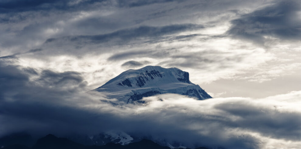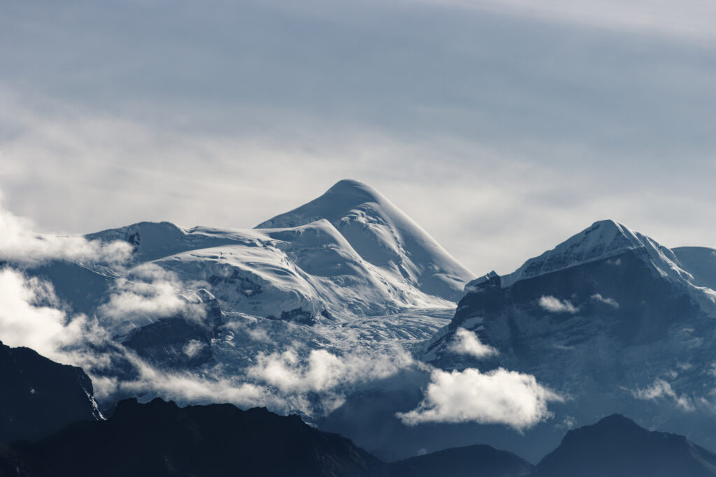
This trek offers challenging and adventurous trekking around Annapurna peaks with an ascent of a technically straightforward peak, Chulu East at 6200 meter. The summit of Chulu East provides the most breathtaking views of Annapurnas II, III and IV, Gangapurna, Glacier Dome, Dhaulagiri, Tilicho Peak and Manaslu. We start the trek from Besi Sahar after a 6-7 hrs drive from Kathmandu. The trail ascends gradually along the Marshyangdi river valley and eventually leads to the village of Pisang where we leave the main trail and head up the Chulu East base camp. Fully physically fit and acclimatized, we then attempt Chulu east. Following an ascent, we rejoin the main trail and head towards Kali Gandaki valley crossing a high Thorung La pass at 5416 meter. Thereafter, we make final descent to Jomsom and take a flight to Kathmandu via Pokhara. The trek provides a great range of landscapes and cultures as we progress from terraced rice fields of Besi Sahar to lush green foothills through alpine forests and barren arid region of the Manang Valley. Along the trekking trail as we walk past fascinating villages, we witness varied cultural settings and ethnic diversity. Most of the climbing will involve walking roped together, including a glacier crossing.
Overview
This trek is challenging & Adventurous trekking.
Best views of Annapurna (II,III & IV), Gangapurna, Glacier dome, Dhaulagiri, Tilicho peak & Manaslu.
|
|
Trip Highlight
- Can be done Annapurna trek along with Chulu East 6200m
- Marshyandi River Valley.
- Thorangla Pass 5416m
Itinerary
Company Staff will be at airport to pick up you and drive you to the Accommodation.
Kathmandu, being a historical and cultural heart of Nepal, is a popular destination for tourists, trekkers and adventure seekers.
Along with exploring Kathmandu we will ready the Permits & required documents as well.
We drive along the Kathmandu-Pokhara Highway to Dumre and then follow the rough road by the Marsyangdi River to Besi Sahar and then to the Bahundanda
On this day we will walk to the place called jagat with the altitude of 1343m.the hillside high above the river before reaching the village of Hani Gaon. Ahead, the Marsyangdi valley forms a steep V-shape, and we follow the winding mountain path down through Syange and along the river for some distance. The trail then climbs steeply and the path is cut into the sheer cliff-face some 200-300m above the riverbed. Eventually we descend to the stone village of Jagat, situated on a shelf which juts into the precipitous Marsyangdi valley. We camp in the fields beyond the village.
The trail from Jagat descends until it almost reaches the river and then continues through a lush forest. Further ascent leads to sharp-edged cliff facing the river bank. En route, Chyamje comes into picture amid glorious picturesque landscape of waterfall and towering Annapurna mountain ranges. After crossing a suspension bridge, we climb steeply towards the slippery and physically challenging path to Sattale. On treading along a succession of rock-strewn trail, we descend to a grassy riverbank which leads to Tal where we find hotels and teahouses attired with warmth and hospitality. But as we walk away from Tal, path becomes rugged and winding. Then we approach steep forested village of Karte. Meandering along the waterfall-clad cliff, we finally reach Dharapani after crossing a suspension bridge. We camp at Dharapani for the night.
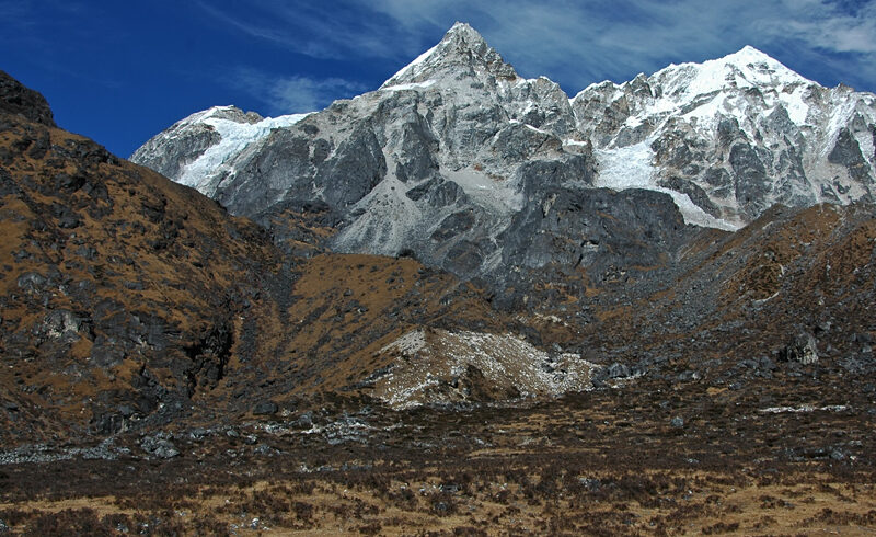
We skirt through a narrow field from the village, the Dudh Khola, which originates from the south face of Manaslu and then Marsyangdi veers to the left. On proceeding along the sinuous trails, we accumulate glorious Annapurna trekking experience. Annapurna II becomes visible as we arrive at Bagarchhap, a Bhote village with prayer flags fluttering in the breeze. As we continue ascending through forests of pine and oak, we pass through Dhanakyu before coming to a thundering waterfall. Further on, the Marsyangdi Khola enters a gorge and the trails follows rock-strewn path. We can pause for a while to bask in the splendor of picturesque Manaslu. When the steep incline ends, we follow a path amid magnificent rhododendrons of Ratamron and then continue on a gently rising path, crossing a stream before entering a pine forest. We then enter pristine hamlet of Kotho from where we can capture the most enchanting view of Annapurna II. Treading further, the route reaches a large white gate with a corrupted iron roof which is an entrance to Chame with altitude of 2685m. Chame is the administrative headquarters for the Manang district. There are electricity, wireless station, school, shops, health post, post office, police check post, hotels, lodges and bank in Chame. Hot springs are the major attraction of this place.
Pisang our next destination with height of 3200m. we cross a large suspension bridge along mystic Marsyangdi and approach houses and lodges on the northern side of the river. Trekking trail routes through barley field leading to Teleku at 2775 meters. As we leave undulating mountain passes, we enter fascinating apple orchard and near a bridge at 2840 meters. On crossing the bridge, a pristine hamlet of Bratang appears. History has it that Bratang used to be a Khampa settlement. Stone memorial of a Japanese climber has been built at this locale. When leaving forested village, the valley changes from a V-shape to a gentle U-shape sprawling before us the majestic vistas of Annapurna mountain range. Further on, we continue our steep rock-strewn trails to the south side and cross a long suspension bridge at 3040 meters. At this vantage point on the bridge, we get to view Paungda Danda rock rising more than 1500 meters from the river. On our route we get to capture splendid views of Annapurna II on the East and Pisang Peak on the north-east. We further cross a bridge and enter lower village of Pisang.
we ascend Chegaji Khola Valley towards Chulu East Base Camp. A gentle ascent through scattered chortens, scrub juniper and stunted pines takes us to the small hamlet of Julu 3500m , sitting on the west bank of the river.
We will explore the place and acclimatize the day
Crossing Cheggi Khola and ascends gradually up the west bank. Soon after trekking for more than an hour, the trail faces a valley and then we encounter a stone hut surrounded by apple trees. We are now bestowed with a stunning view up the side valley that reaches up towards Chulu West. As the valley ends, 500ft cliff stands on the way displaying spectacular sight of waterfalls cascading down the cliff. The trail further steepens and winds through a small meadow. On the way, we come across goat and yak pastures. As the day progresses, we come close to Yak Kharka
the trail wending through steep pastures to a convenient hollow where the meadow merges into rock and scree. Then, there appears the base camp.
we move up to the high camp and there we rest atop the terminal moraine of the Chulu glacier.
The trail up to the high camp follows scree and snow slopes. Resting at the high camp, we take a plenty of time to relax and prepare equipment and strategies for the next day. We will use 2 days for this Day 14 and Day 15
The trail up to the high camp follows scree and snow slopes. Resting at the high camp, we take a plenty of time to relax and prepare equipment and strategies for the next day.
On the day of climbing Chulu East, we make an early start across the undulating glacier as the trail takes snow and ice slopes. As we continue ascending, several peaks come en route. Eventually we run out of mountain at a small snow dome with steep slopes falling away on all sides. At this point, our high camp diminishes to toy-town stature and climbing to such an altitude gives us a feeling of sitting on top of the roof of the world.
On trekking down to Manang, we embrace heavenly vistas of Annapurna range - Annapurna II, Annapurna III, Annapurna IV, Gangapurna [7455m] and Tilicho Peak [7134m]. We camp at the fortified villages of friendly Manang people for the night
Views of Manaslu, the Annapurnas, Tilicho Peak and the Great Barrier are seen . We head north-west up the Jarsang Khola, through scrub juniper and alpine grasses.
Crossing Throngla pass (5416m) we will move towards the Muktinath.